Find Property Lines by Address
Search an address to view the property from above and see parcel boundaries when they’re available. Use the boundary as a reference for lot size, measurements, planning, and understanding where the property sits.
Opens the free measurement tool. No sign-up to start.
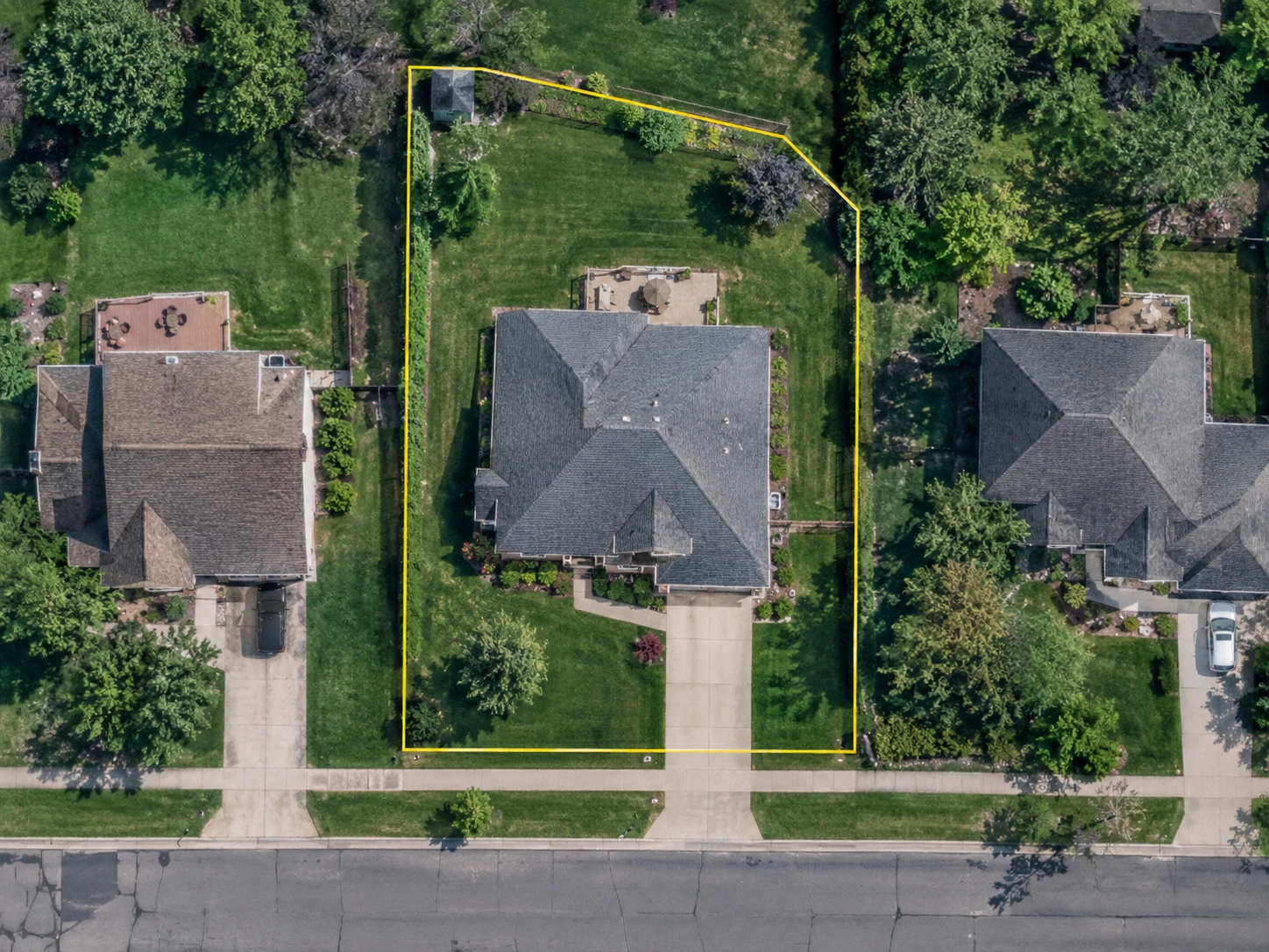
Yes. You can find many property lines online by searching an address and viewing parcel boundary data over a map or aerial image. Those lines come from parcel and GIS records rather than from the satellite image itself. They’re useful for reference, planning and measurement, and they aren’t a legal survey.
What you’re actually looking at.
A satellite can photograph a roof, a driveway, a fence and a hedge. It can’t photograph a property line, because a property line isn’t a physical thing. It’s a boundary written down in records.
So a map that appears to show property lines on satellite imagery is really showing two separate things stacked on top of each other. The photograph shows what exists. The parcel layer drawn over it shows where the records put the edge of the lot.
That distinction is worth holding on to, because nearly every question people have about online property lines comes back to it. Coverage, accuracy and alignment are all facts about the second layer, not about the picture underneath.
Aerial image
Shows the visible features. Roofs, driveways, lawns, trees, fences, kerbs and roads, as they were on the day of the capture.
Parcel boundary
Shows the mapped shape of the parcel, drawn from recorded parcel data rather than from anything in the photograph.
Together
Lets you compare the recorded boundary against what is actually on the ground, and measure either one.
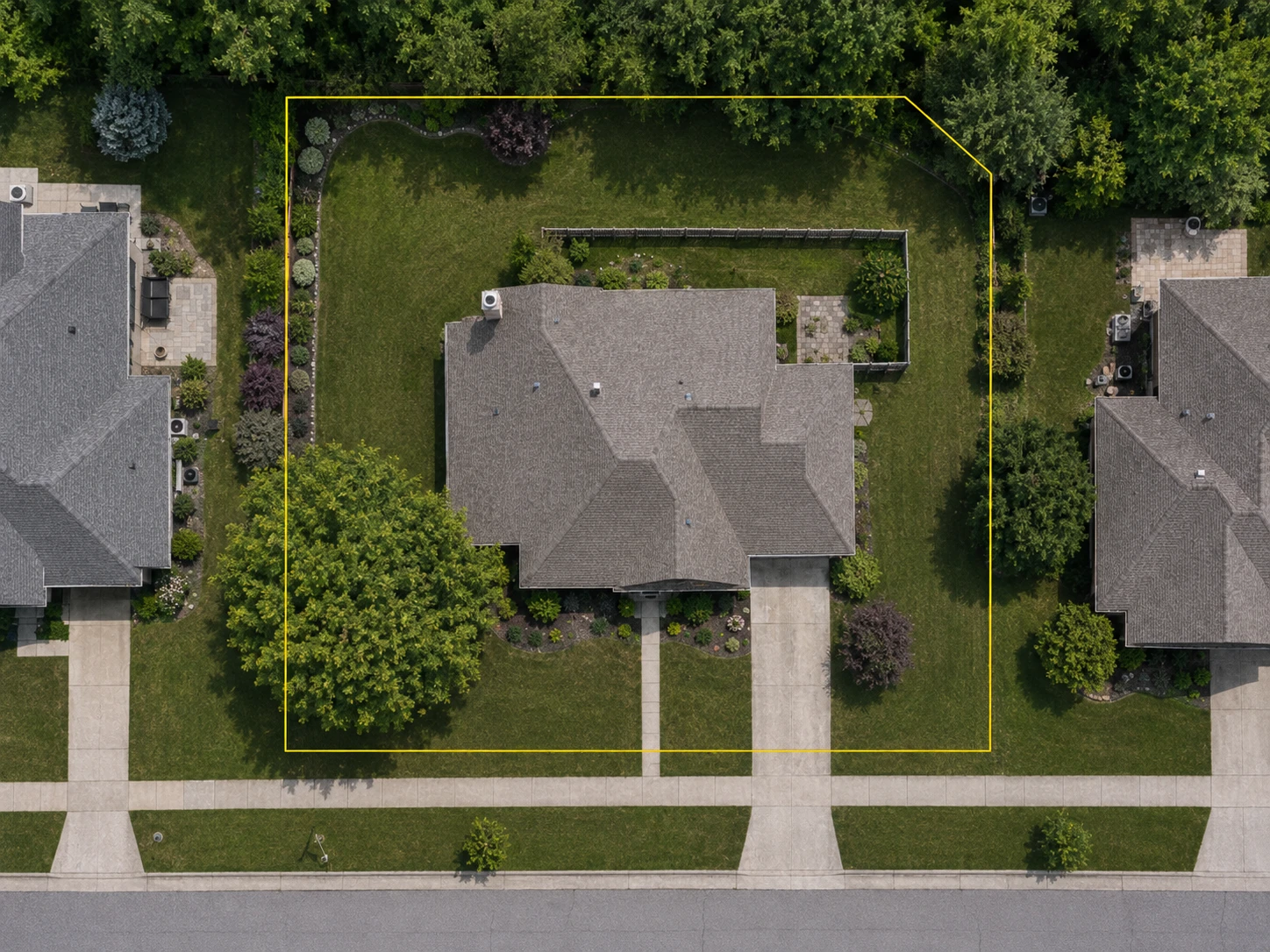
- 1Parcel boundary
- 2Fence inside parcel
- 3Sidewalk outside parcel
How to find property lines online.
Search the property
Enter the street address and open the property. Zoom in far enough to tell the house, the road and the neighboring lots apart before you look at anything else.
Find the parcel
Check that the parcel on screen is the one you meant. An address and a parcel are not always the same object: corner lots, flag lots, units inside a larger land parcel and recently split properties can all resolve to something you would not have pointed at.
Turn on or inspect the boundary
View the parcel outline over the aerial image where boundary data is available. In FindPropertySize the parcel layer is on by default, so most of the time it is already drawn.
Compare it with the property
Look at where the line falls against the house, the driveway, the fences, the tree line and the road, and at how it meets the parcels either side. That comparison is usually what you came for.
Measure if you need a figure
Trace the lot or any area inside it to get its area in square feet, square metres, acres or hectares, or a project estimate. What you trace is your decision: it can follow the boundary, sit well inside it, or ignore it entirely.
Verify when precision matters
Use recorded documents or a licensed surveyor when the exact legal position of the line is what a decision turns on. That is a different job from anything a map can do.
People assume the fence is the line. It often isn’t.
It’s the first thing almost everyone does. You look at the back fence, or the hedge, or the point where the mowing stops, and you take that to be the edge of what you own.
Sometimes that’s exactly right. Plenty of fences were set on the line by somebody who knew where the line was. Plenty of others weren’t, and the reasons are ordinary. A fence gets built a foot or two inside the boundary so the far side can be maintained without stepping onto a neighbor’s land. A previous owner put it where the ground was easy. A hedge was planted for privacy rather than for surveying. A driveway was widened and the lawn edge moved with it. Somewhere in the middle of all that, an easement or a setback runs across land that is genuinely yours and still has rules attached to it.
A parcel overlay helps here, and it helps most in the case that is easiest to miss: where a fence and a boundary agree along one side of a property and quietly part company along another. What it can’t do is settle the question, because it is recorded reference data rather than a determination of where the line legally runs.
Parcel line overlays are currently available for properties in the U.S. and Canada. Measuring works anywhere in the world.
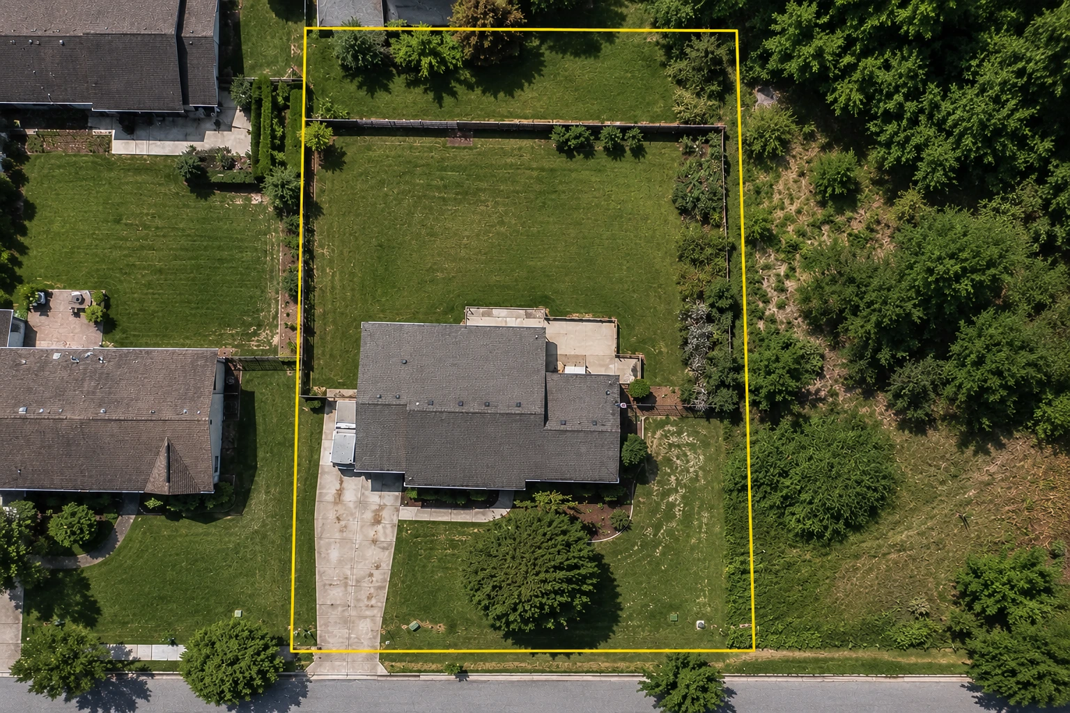
- 1Parcel boundary
- 2Fence
- 3Visible yard edge
Why the line can look shifted on the map.
The parcel layer and the photograph underneath it are made by different people, at different times, by different methods. Nothing in the process forces them to agree.
Parcel geometry is usually digitised from recorded documents, plats and older maps, then fitted to the ground as well as the available control allows. Aerial imagery is captured on its own schedule, stitched together from many frames, and corrected for terrain and camera angle. Each one is doing its own job carefully. Neither is being drawn against the other, and the two can be described on slightly different map projections before they ever reach a screen.
So an overlay landing a few feet off a fence doesn’t prove the fence is in the wrong place, and it doesn’t prove the parcel record is wrong either. Most of the time it means the two layers disagree about where one point on the ground belongs. That’s a mapping fact, not an ownership fact, and the tell is usually that the whole boundary is shifted by roughly the same amount in roughly the same direction.
A small offset isn’t evidence
If you’re measuring, pick the edge you actually mean and follow that one all the way round. Averaging a parcel line against a fence gives you a boundary that matches neither of them, and a shape nobody can check afterwards.
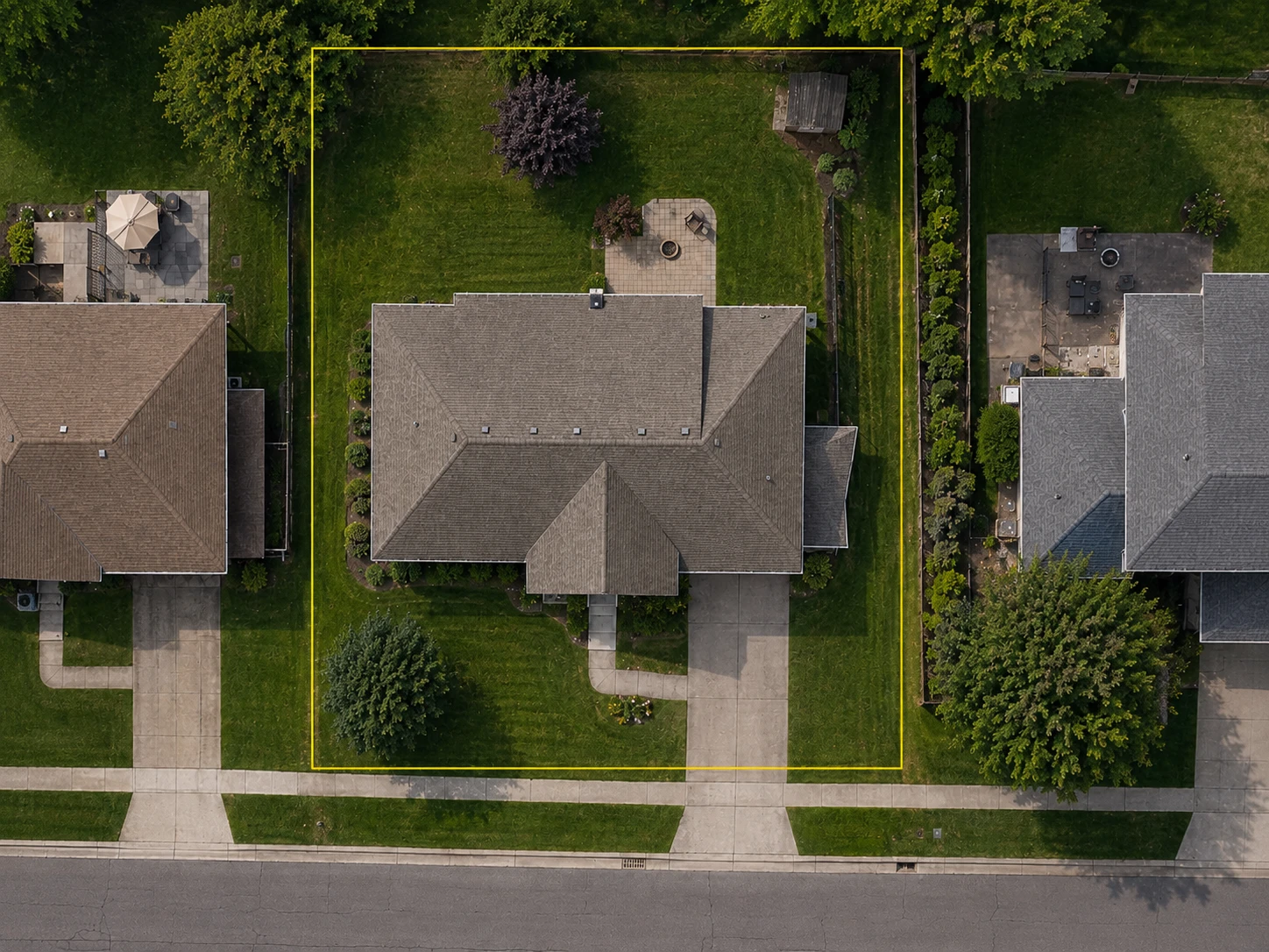
- 1Parcel data
- 2Apparent visual offset
- 3Visible yard features
Property line, parcel line, lot line: what people mean.
In conversation these are used interchangeably, and most of the time that’s fine. Where it stops being fine is when the source matters, because the records behind them are not always the same records.
| Term | What people usually mean | Worth knowing |
|---|---|---|
| Property line | The edge of what somebody owns, where one property meets the next. | The general term, and the one people search for. It says nothing about where the information behind the line came from. |
| Parcel boundary | The shape of the parcel as it is recorded and mapped, usually for assessment. | This is what an online overlay draws. A parcel is a record, and a record can lag what has happened on the ground. |
| Lot line | The edge of a lot as laid out on a recorded plat or subdivision map. | The usual term in zoning and permitting, where front, side and rear lot lines are treated as separate things with separate rules. |
| Fence line | Where a fence physically stands. | A structure, not a boundary. It either agrees with the line or it does not, and it cannot tell you which. |
| Surveyed boundary | The line as located on the ground by a licensed surveyor. | The only entry here that is a professional determination rather than a map, a record or an object. |
Definitions also vary by jurisdiction. A parcel drawn for tax assessment and a lot drawn on a subdivision plat are answering slightly different questions about the same piece of land, and in some places the two are maintained by different offices. If a document uses one of these terms precisely, it’s worth finding out which one it means.
Where online property boundaries come from.
Parcel geometry starts with local government. County assessors, recorders and GIS departments maintain the parcel maps for the land they’re responsible for, largely so property can be assessed and taxed, and most of them publish that data in some form.
There are a few thousand of those offices in the United States and they don’t share one system, one schedule or one standard. That’s the problem data providers exist to solve: collect what the local sources publish, normalise it into one shape, and pass it on to the maps people actually use. FindPropertySize draws its parcel layer that way, as a mapping and reference layer over the imagery.
Which is why coverage and freshness vary from place to place. Some counties publish detailed geometry and revise it often. Some publish less and revise it rarely. If no boundary appears for a property, that’s usually a fact about what’s available there rather than about the address you typed, and you can still measure the property from the imagery.
Parcel line overlays are currently available for properties in the U.S. and Canada. Measuring works anywhere in the world.
Can Google Maps show property lines?
Not as a feature you can switch on. There’s no property boundary layer in Google Maps and no setting for one.
What people are usually remembering is one of two things. Zoom in far enough in some areas and the base map draws faint grey lines around individual lots, which come from public data and are there as map detail rather than as a boundary product. Or they’re thinking of Google Earth Pro, where you can import a KML file from a county GIS site and see that county’s parcels over the imagery.
Both of those work as far as they go. Neither gives you a boundary you can look up by address in every area, which is the gap a dedicated parcel map fills, and the same gap a county GIS portal fills if you’re willing to learn a different website for every county.
How accurate are online property lines?
There isn’t one number, and anybody quoting you a single figure for the whole country is guessing. Accuracy is a property of the parcel record for the place you happen to be looking at, and those records were made in very different circumstances.
Geometry digitised from a recent, well controlled survey lands closer than geometry traced off a hand-drawn plat. A parcel nobody has revisited since the subdivision was recorded carries whatever was known at the time. Long rural parcels described by metes and bounds accumulate more error along their run than a small platted rectangle does. And the imagery underneath has its own alignment, which is a separate question from whether the record is right.
The practical version: an online boundary is usually good enough to tell you what shape a lot is and roughly where it runs. It isn’t good enough to tell you where to put a post.
| Fine as a reference | Verify before you act |
|---|---|
| Working out roughly how big the lot is | Recording an exact acreage in a document |
| Seeing the parcel’s shape and how it sits against its neighbors | Locating the actual corners on the ground |
| Quoting lawn, paving or landscaping work well inside the property | Building a structure up against the line |
| Deciding roughly where a fence would go | Setting the posts on the line itself |
| Getting oriented before a site visit or a conversation with a neighbor | Settling a disagreement about where the line runs |
A boundary and a measurement answer different questions.
A parcel boundary tells you where the records put the edge of the lot. A measurement tells you how much of something is there. Those two come apart more often than people expect.
Somebody quoting sod cares about the lawn, and the lawn is a fraction of the parcel. Somebody pricing a resurfacing job traces the driveway and nothing else. A homeowner checking acreage wants the whole parcel and nothing less than it. Somebody planning a shed wants the boundary visible the entire time they’re measuring something completely different, because the boundary is the constraint and the shed is the work.
So the two are separate things in FindPropertySize. The parcel layer is context you can leave switched on while you work. What you trace is your decision, and it can follow the boundary, sit well inside it, or ignore it entirely.
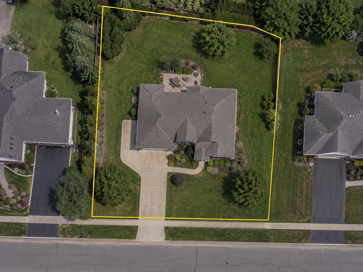
- 1Property boundary
- 2Area being measured
When you need a survey.
An online parcel map is not a legal survey, and no amount of zoom turns one into the other. A survey is a licensed professional locating the boundary on the ground and standing behind that determination.
The situations that call for one are fairly specific. A disagreement with a neighbor about where the line runs. Construction close enough to a boundary that a couple of feet changes the answer. Fence placement where exact position matters. A legal description for a document. Locating the official corner markers. A transaction where boundary certainty is part of what’s being agreed.
Short of a survey there are other authoritative sources worth knowing about. Your deed carries the legal description of the property. A recorded plat shows the lot as it was laid out. If the property has been surveyed before, the corner pins may still be in the ground and the survey itself may be on file. County records are where most of that lives, and they are a better place to start than any map.
A boundary on a map is a record, not a determination.
Use recorded documents and a licensed surveyor where the exact legal position of a property line is what a decision turns on. For everything short of that, a parcel boundary over aerial imagery is a genuinely useful thing to have on screen.
What a boundary is good for.
Contractor estimates
Keep the parcel on screen while you measure the part of it you are actually quoting: turf, pavement, beds, roof.
Property planning
Get the scale and shape of a property before planning work on it or discussing it with somebody else.
Lot size
Understand the whole parcel, including the parts a fence or a hedge quietly leaves out of what you think of as the yard.
Homeowners
See where the property sits against its neighbors and against the things you can point at from the garden.
Property line questions
Can I find my property lines online?
Usually, yes. Searching an address on a parcel map shows the recorded boundary of that property over a map or aerial image, and county GIS sites publish the same kind of data. Coverage is not universal, and what you get is a mapped record rather than a surveyed line.
How do I find property lines by address?
Search the street address, confirm that the parcel on screen is the property you meant, and view the parcel outline over the aerial image. From there you can compare the boundary with the house, the driveway and the fences, and measure the lot or any area inside it.
Can I see property lines on a satellite map?
You can see a boundary drawn over satellite imagery, which is not quite the same thing. The imagery shows physical features, and the boundary is parcel data drawn on top of it. A satellite cannot photograph a property line, because a property line is a recorded boundary rather than an object on the ground.
Does Google Maps show property lines?
There is no property boundary layer in Google Maps and no setting to switch one on. At high zoom in some areas the base map draws faint grey lines around individual lots, and Google Earth Pro can display a county’s parcels if you import a KML file from that county’s GIS site. Neither is a boundary you can look up by address everywhere.
Are online property lines accurate?
Accurate enough to understand a property, and not accurate enough to build against. How close a line runs depends on the records behind it, when they were made, how the geometry was digitised and how the imagery underneath is aligned, all of which vary by county. Treat an online boundary as a good reference and confirm it before anything that depends on its exact position.
Is a fence the same as a property line?
No. A fence is a structure, and where it stands is a fact about who built it and when. Some fences were set on the line by someone who knew where the line was. Others were set inside it, outside it, or where the ground made it easy. The fence cannot tell you which of those happened.
Why don’t the property lines match my fence?
Either the fence is not on the line, or the two layers on your screen do not agree with each other, and both are common. Parcel geometry and aerial imagery come from different sources and are aligned by different methods, so an overlay can sit a few feet off a visible edge without either the fence or the record being wrong.
What is a parcel boundary?
The mapped outline of a parcel of land as it is recorded, usually by a county assessor or GIS department for assessment and public reference. It is the shape most online property line maps draw. Parcel, lot and property line get used interchangeably in conversation, and the records behind them are not always the same records.
Can I use online property lines to build a fence?
To plan one, yes. To place the posts, no. An online boundary will tell you roughly where the fence would run, how long it needs to be and what it would enclose, which is enough to price the job. Where the exact position matters, and it usually does on a boundary fence, confirm the line with recorded documents or a surveyor first.
Do I need a survey to find my exact property line?
For the exact line, yes. A survey is a licensed professional locating the boundary on the ground and standing behind it, and nothing on a map replaces that. Short of one, your deed carries the legal description, a recorded plat shows the lot as it was laid out, and any earlier survey of the property may still be on file with the county.
Related property measurement tools
Want to see the property lines?
Search the address and view the property from above. When parcel data is available, use the boundary as context for your measurements.
No sign-up to start.